Inertial Surveying & Mapping of Subaqueous Pipelines
Unveiling the Future of Pipeline Mapping
Welcome to the future of subaqueous pipeline mapping as we give you a behind-the-scenes look into the challenges encountered by the FDOT during its ambitious replacement of two critical bridges spanning the Florida Gulf Intercoastal Waterway.
In this comprehensive guide, we'll unravel the complexities of accurate 3D mapping, emphasizing its pivotal role in averting potential disaster during bridge construction.
With real-world examples and meticulous detail, this is your opportunity to discover how WGI leveraged innovative technology and solutions to seamlessly map subaqueous utilities in the replacement of both the John T. Brooks and Theo Baars bridges.
At the Forefront of Innovation
From initial surveying to final deliverables, each stage of our surveying process has been meticulously outlined to provide you with invaluable insights into our innovative methodologies. Don’t miss your opportunity to:
- Witness the groundbreaking application of inertial navigation technology, a game-changer in pipeline mapping.
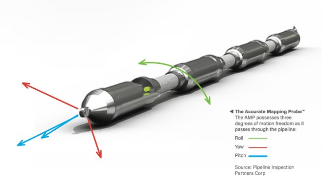
- Learn how our Accurate Mapping Probe (AMP), armed with state-of-the-art gyroscopes, accelerometers, and inclinometers, navigated the underwater depths with unparalleled precision.
- Explore the science behind inertial navigation systems to better understand the intricacies of acceleration, angular velocity, and attitude determination.
Plus, we’ll give you an exclusive look into the rigorous testing and validation processes designed to ensure the utmost accuracy amidst varying pipeline configurations and environmental factors.
Leaders in Subaqueous Surveying
Whether you play an active role in infrastructure design and development, surveying, or are simply curious about the latest cutting-edge technologies in action, this whitepaper is a must-read with exclusive case studies at the forefront of pipeline mapping.
Download Our Whitepaper:
Inertial Surveying & Mapping of Subaqueous Pipelines
And discover how inertial surveying is reshaping the landscape of infrastructure projects and ensuring the safety and success of construction endeavors everywhere!