Before or After the Fact
Geospatial Imaging is Critical for Disaster Preparedness, Response, and Recovery
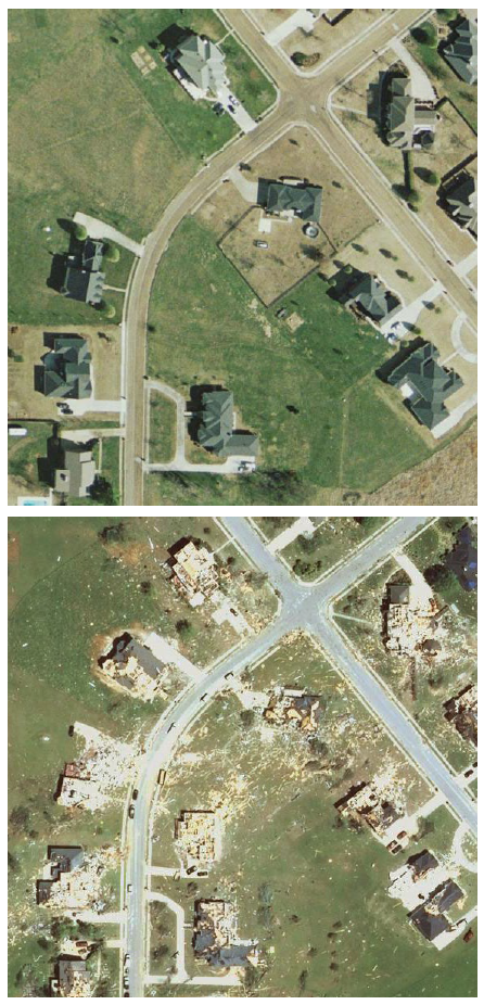
Disaster strikes without warning, and in those crucial moments, every second counts. And with a record-breaking hurricane season on the horizon, the urgency for comprehensive disaster preparedness, response, and recovery plans has never been more pressing.
Yet, disaster management is not confined to a single season. In our latest whitepaper, we delve into the pivotal role of geospatial technology in disaster management. From wildfires and floods to earthquakes and tornadoes, this cutting-edge technology offers indispensable insights before, during, and after even the most catastrophic of events.
.png)
A Snapshot of What’s Inside
Uncover the Power of Geospatial Technology:
- Discover the critical role of geospatial imaging in providing vital intelligence for disaster response and recovery efforts. Explore how this groundbreaking technology offers before-and-after insights, facilitating situational analysis, resource allocation, risk assessment, and so much more.
WGI's Cutting-Edge Geospatial Offerings:
- Delve into WGI's state-of-the-art geospatial offerings, including indoor and outdoor lidar imaging, mobile lidar for accurate roadway mapping, real-time flood forecasting utilizing Floodwise™ and Stormwise™ technologies, as well as airborne lidar and imagery.
Real-World Case Studies in Disaster Response:
- Immerse yourself in real-world examples and explore WGI’s invaluable impact during times of crisis firsthand - supporting the U.S. Army Corps of Engineers during severe flooding along the Mississippi & Arkansas Rivers, aiding the state of Alabama in assessing the impacts of Hurricane Isaac, and so much more.
Download Our Whitepaper
In the face of uncertainty, one thing is clear: preparation is key…. So, don't wait until it's too late. Be proactive, be prepared, and download our whitepaper to take the first step towards a safer, more resilient tomorrow.
Download Our Whitepaper:
Before or After the Fact
We're more than just a geospatial solutions provider; we're your partners in disaster preparedness and recovery. With our expertise and advanced technology, you can ensure that you're always one step ahead when disaster strikes.